

Essex Green is pretty centrally located in town. It’s also almost entirely cut off and isolated from the town.
Whether you’re trying to hang out at the shopping plaza with your friends or get to the library tucked away in the back, it’s tough to get there if you’re on foot or on a bike.
One major county road – Prospect Ave – provides access to the area. But as you go north from St. Cloud, the road is narrow and there are no sidewalks. And if you’re coming south from Eagle Rock, there is no safe way to navigate the interchange with I-280.
The other major county road that provides access to the area is Mt. Pleasant Ave. So this week, I decided to run up that way and see what it was like. Parts of it were fine – but one particular segment is unsafe. See the map and keep reading below for the details.
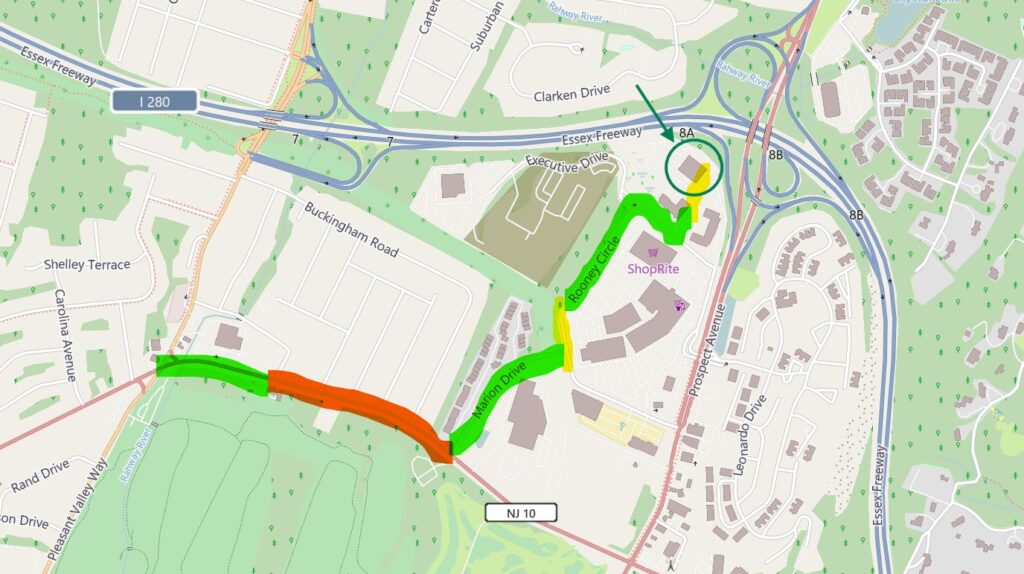
From Pleasant Valley Way to Essex Green
I ran from my house – down by the zoo – up to the intersection of PVW and Mt. Pleasant. That’s a story for another day. But we’ll start there because it’s an access point that would be convenient and relevant for anyone living near Mt. Pleasant Elementary school or in the Englishtown neighborhood.
When you head east from the intersection, the strip of road that fronts the shopping complex (Bagels by Jarrett and soon to be Trader Joes) has a decent sidewalk.
Once you get past the plaza, though, the sidewalk ends. From Mt. Pleasant Place up to Marion Drive – about a quarter of a mile – there are no sidewalks. The road itself is four lanes across, and it can get quite busy at times. There’s no shoulder, and if there’s a car in the right hand lane, you need to hop on to the grass on the side of the road.
This puts you in people’s front yards. One or two houses had some stones put down like a make shift walking path. In other yards, you can clearly see where the grass is worn down from people walking. It definitely gets use.
If you’re in the back of that neighborhood – on Buckingham Drive – you could exit out on to Mt. Pleasant from Wedgewood Drive. But you’ve still got a block to go along Mt. Pleasant before you get to Marion Drive.
It’s also worth pointing out that if you were to do this in reverse – from Essex Green down to Pleasant Valley Way – it’s much worse. You can’t feasibly walk on the other side of Mt. Pleasant, which means that you’re walking, running, or riding your bike with your back to oncoming traffic. On a busy road with no shoulder, that’s a big problem.
Once you get to Marion Drive, though, things improve quite a bit. There’s a nice sidewalk on the east side of the road that takes you up towards Essex Green.
Around Essex Green Towards the Library
When you get to the top of Marion Drive and the intersection with Rooney Circle, you’ve got a choice. You could head to the crosswalk towards the right and cross directly into the shopping plaza (near Petco and AMC). Or you could turn left and follow Rooney Circle around towards the library.
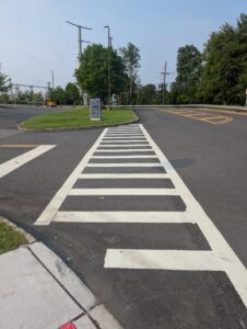
If you go to the left, there is a stretch of Rooney Circle without a sidewalk. Once you get to the next driveway – which enters the parking lot towards Hook and Reel – the sidewalk resumes. It starts with the crosswalk from nowhere (see the picture to the right).
That sidewalk will continue all the way around ShopRite and past Starbucks. It connects to a crosswalk that takes you in between the Cambria and the Courtyard, and a sidewalk will continue along the side of the Cambria … almost all of the way to the library.
That sidewalk ends in the back of the Cambria parking lot, only about 150 feet from the walkway at the top of the West Orange Public Library parking lot next to the handicap parking.
Making the Library More Accessible
Whether you’re happy with the library’s new location or not, it is what it is. Our focus now should be on making it more accessible.
Part of this area has been improved in the last year. The Essex Green shopping plaza has seen some upgrades. The crosswalk over Rooney Circle near Marion Drive and the sidewalk that goes around the back of the ShopRite are both new.
But it seems like a silly oversight that the sidewalk doesn’t connect from Marion Drive all the way to ShopRite. On the other side of the shopping plaza, there’s no good accessible route to get from the library to the bus stop on Prospect. You could walk there by cutting through the parking lot, but there are sections that would be difficult to navigate in a wheelchair.
Then there’s the actual parking lot of the West Orange Public Library. It definitely needs improvements, and if we’re going to be doing that work it seems like a no-brainer to connect the parking lot with a crosswalk and sidewalk over to the back of the Cambria.
Those are all minor issues, though. The big issue is Mt. Pleasant. In it’s current state, it’s unsafe to walk or ride your bike up that stretch of road. That effectively cuts off this means of access.
The Englishtown neighborhood is a mile or less from the library – well within walking distance. Up the hill near Mt. Pleasant elementary is within two miles – a long walk or an easy bike ride. Most of Pleasantdale near the high school is within two miles, too.
There are lots of potential improvements you could make. But simply installing a sidewalk along that quarter mile stretch from Mt. Pleasant Place to Marion Drive would be a good first step.
And if you think no one will use it, consider this. I ran through here in the morning, and later in the afternoon I drove by in my car. There was a teenager riding his bike up Mt. Pleasant, weaving on and off the road to avoid oncoming traffic. I don’t know where he was headed, but he was navigating this exact stretch of unsafe road.
Read more here about my commitment to Complete Streets and pedestrian safety.